Surviving Natural Disasters
Surviving a Natural Disaster requires a skillset that includes some or all of the following elements:
- understanding the natural disaster
- becoming aware of the approaching natural disaster
- mental survival strategy
- physical survival strategy
- flee the disaster or shelter in place
- recovering from the natural disaster
So, basically, surviving a natural disaster is a multistep process which integrates the above elements before, during and after the disaster strikes. Using MyPlan4Survival to create a customized survival plan for the natural disaster in your future will help provide you with the confidence necessary to weather the storm.
Surviving Natural Disasters - Cyclones, Hurricanes and Typhoons
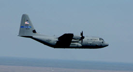
 Lockheed Martin WC-130J Hercules hunts hurricanes.
A tropical cyclone is a rotating low-pressure weather system of organized thunderstorms without a front. Cyclones, Hurricanes, and Typhoons are all categorized as tropical cyclones, the only difference being where they occur. A hurricane usually originates in the Atlantic Ocean, Caribbean Sea, Gulf of Mexico, or Northeastern Pacific Ocean, but less frequently they can originate in the North Central Pacific Ocean. A typhoon originates in the North Western Pacific Ocean. A cyclone originates in the Indian Ocean or South Pacific Ocean. The only difference between a cyclone, hurricane, and typhoon is where they occur. The characteristics of the storm are the same.
If you are living in the USA in an area that is vulnerable to cyclones, hurricanes, or typhoons, visit the National Hurricane Center and the Worldwide Tropical Cyclone Center on a frequent basis. Check the graphics of each active storm and review the most recent advisories for each of the active storms to see if you are, or will be, in the path of the storm. For additional information on extreme weather events throughout the world, see the Worldwide List of Extreme Weather Events.
Both mental and physical preparation is required to survive natural disasters like cyclones, hurricanes and typhoons. Mentally be aware your situation - where you are geographically with respect to the oncoming storm, do you plan to flee or shelter in place, an escape route to a safe destination, and transportation available to get you to that safe destination. Physically be prepared with quick access to food, water, shelter and transportation. Some ideas include; Assembling a kit with essential supplies such as food, water, bandages, batteries, cell phone and charger, and cash. Credit and debit cards will not be your best bet if the storm causes an electronic payment system outage. Create a list of items and take photos of these items in your house and verify what your insurance will cover. If you choose to evacuate, decide where you would move to and how to get there. In the case you would not be able to drive to your safe destination, find out which bus, train, or plane routes would help you arrive there. When the storm threatens your area, attempt to protect your home from storm damage. If any local or state evacuation orders are given, comply with them. If you had planned to travel to an area at the mercy of a cyclone for vacation, cancel or reschedule your vacation to a different date. If you were to travel to an area under the threat of a storm for work-related business, consider virtual options if postponing is not possible. Should you decide to shelter in place protect yourself from high winds and flooding using a storm shelter or interior room. If trapped by flood water go to the highest floor of the building you are in. Don't shelter in a closet as you may be trapped by flood waters. Stay out of the flood waters. Even very low levels of flood water are dangerous and are notorious for containing biologic pathogens and swift currents in which you may drown. Do not return to the threatened area until you are informed that it is safe to do so. Continue to be watchful of any potential hazards such as downed power lines or phone lines, unknown bodies of water, or remaining debris from the storm.
General information concerning the mental and physical preparation required to survive cyclones, etc. maybe be found on The Psychology of Survival page of this website. Additional information specific to surviving cyclones, hurricanes and typhoons may be found on the U.S. Federal Government Ready Dot Gov website.
Surviving Natural Disasters - Tornadoes
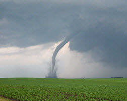
 A tornado displaying a condensation funnel.
According to the NSSL (NOAA National Severe Storms Laboratory) "A tornado is a narrow, violently rotating column of air that extends from a thunderstorm to the ground." A tornado is usually visible as a funnel cloud, but tornadoes are known to exist with no visible funnel cloud. Typical tornadoes we see in movies or on the weather report are visible as the tornado itself is a condensation funnel made up of water droplets, dust, debris and a young girl named Dorothy and her dog Toto from Kansas. Tornadoes occur all over the world, in North and South America, Europe, Asia, Australia and Africa. The United States gets hit with about 1200 tornadoes per year with many of these tornadoes occurring in Tornado Alley located in the central USA. Typically, in the USA, tornadoes appear in the Southeast in the cooler months of the year, moving to the Central Plains in May and June and ending the season in the Northern Plains and Midwest in early summer. Be aware, tornadoes have been reported in all 50 states of the USA.
Tornadoes can pop up unexpectedly and without much warning. Some warning signs of tornado activity are:
- Condensation Funnel - consists of water droplets that extend downward from the base of a thunderstorm and will usually have dust and debris near the ground at the bottom of the funnel.
- Inflow Bands - jagged bands of low cumulus clouds extending from the main part of the thunderstorm and usually pointed south or southeast. Inflow bands appear to be spiralling or rotating.
- Wall Cloud - an isolated cloud coming down from the rear of the storm in a rain free area that resembles a wall. A wall cloud may rotate and move quickly in a vertical direction.
- Rear Flank Downdraft - air rushing downward at the back of the thunderstorm that looks like a bright clear slot at the rear of a wall cloud. It can also resemble curtains of rain wrapping around the base of the storm clouds.
Tornado Watch/Warnings in the United States:
- Tornado Watch - issued by the NOAA Storm Prediction Center. A watch may cover several states or just parts of one state at a time. Tune to NOAA Weather Radio to discover when a tornado watch has been issued for your area.
- Tornado Warning - issued by your local National Weather Service Forecast Office. A tornado warning means you better find shelter quickly as a human spotter or weather radar has detected a tornado in your area. One or more counties may be affected by this warning. Take care to protect yourself and, if possible, your property from the serious threat presented by a tornado.
Tornado Watch/Warnings in Australia:
- Australia usually sees between 30 and 80 tornadoes each year. Supercell tornadoes are most common in Central and Eastern New South Wales, Southeast Queensland and Northeast Victoria. Keep track of tornado activity in Australia by visiting the Australian Bureau of Meteorology.
Stripe 3 — Subheadline

A Text/Image Block. Praesent quis fringilla turpis. Maecenas quam tortor, dapibus eget mollis et, facilisis at mi. Aenean non risus non velit placerat pretium. Donec vehicula faucibus diam, vitae tempus arcu porttitor non. Nam sit amet mauris id sem rhoncus placerat a ac nibh. Donec fermentum mauris eget ligula faucibus rutrum. Nullam dolor nisi, congue sed blandit elementum, porta nec velit. Quisque nec adipiscing tortor. Integer auctor laoreet laoreet. Cras non ultricies mauris. Cum sociis natoque penatibus et magnis dis parturient montes, nascetur ridiculus mus. Curabitur quis sem vitae felis pulvinar condimentum nec nec neque.